Navtex-områden: En Djupdykning i Maritim Säkerhet
Vad är Navtex och Navtex-områden?

Navtex (Navigational Telex) är ett internationellt automatiserat medium för att sända ut navigations- och vädervarningar, samt prognoser och säkerhetsmeddelanden till fartyg. Systemet är en viktig del av det globala sjösäkerhetssystemet (GMDSS). För att effektivt hantera och distribuera denna information, är havet uppdelat i specifika Navtex-områden. Dessa områden säkerställer att sjöfarare får relevant information baserat på deras geografiska position.

Varje Navtex-område betjänas av en eller flera kustradiostationer som sänder ut meddelanden. Dessa meddelanden täcker en rad ämnen, inklusive:
- Navigationsvarningar: Information om hinder, grund, vrak eller andra faror för navigeringen.
- Väderrapporter och prognoser: Aktuell väderinformation och förutsägelser för att hjälpa sjöfarare att planera sina resor.
- Säkerhetsmeddelanden: Information om sök- och räddningsoperationer, piratverksamhet eller andra säkerhetsrelaterade händelser.
- Israpporter: Viktigt för fartyg som opererar i isfyllda vatten.

Hur Navtex-områden Definieras och Fungerar
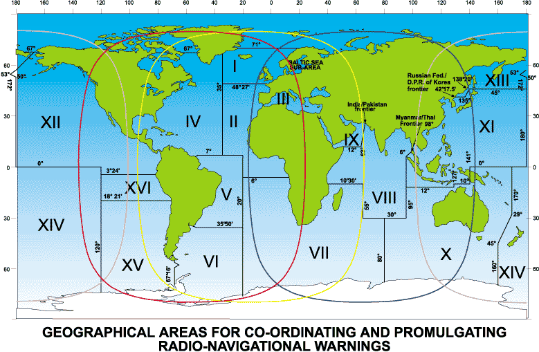
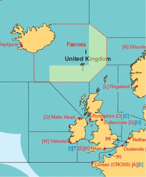
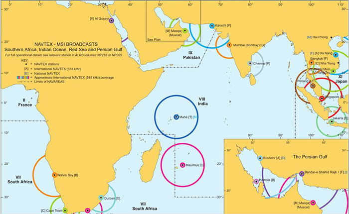
Navtex-områden är globalt definierade och numrerade, vilket gör det enkelt för sjöfarare att identifiera relevanta områden. Varje område har en unik identifieringsbokstav som används i meddelandehuvudena, vilket gör det möjligt för mottagare att filtrera och välja relevanta meddelanden.
Systemet fungerar genom att kustradiostationer sänder ut meddelanden på en frekvens av 518 kHz (internationell Navtex-frekvens). Mottagare ombord på fartyg tar emot dessa meddelanden och visar dem på en skärm eller skriver ut dem. Moderna Navtex-mottagare kan programmeras för att filtrera bort irrelevanta meddelanden baserat på område och meddelandekategori.
Det är viktigt att förstå att Navtex-områden inte alltid följer exakta geografiska gränser. De är utformade för att säkerställa att relevant information når sjöfarare inom ett visst avstånd från kustradiostationerna.
Betydelsen av Navtex-områden för Maritim Säkerhet

Navtex-områden spelar en avgörande roll för att säkerställa säkerheten till sjöss. Genom att tillhandahålla aktuell och relevant information, hjälper de sjöfarare att undvika faror, planera säkra rutter och reagera på nödsituationer.
I en värld där sjöfarten blir alltmer komplex och trafikerad, är tillförlitlig information avgörande. Navtex-områden säkerställer att denna information är tillgänglig för alla fartyg, oavsett storlek eller typ.
För yrkesfartyg, fritidsbåtar och alla som färdas på havet är kunskap om Navtex-områden och förmågan att tolka Navtex-meddelanden av yttersta vikt.
Tolka Navtex-meddelanden
Varje Navtex-meddelande följer en standardiserad struktur. För att tolka ett meddelande, måste du förstå de olika delarna:
- Startbokstav: Identifierar kustradiostationen som sänder meddelandet.
- Ämnesbokstav: Anger typen av meddelande (t.ex. navigationsvarning, väderrapport).
- Meddelandenummer: Ett unikt nummer för att identifiera meddelandet.
- Meddelandets text: Själva informationen som sänds ut.
- Slutmarkering: Anger slutet på meddelandet.


Att kunna tolka dessa meddelanden korrekt är avgörande för att förstå den information som förmedlas.
Slutsats
Navtex-områden är en central del av det globala sjösäkerhetssystemet. Att förstå hur dessa områden fungerar och hur man tolkar Navtex-meddelanden är avgörande för alla som färdas på havet. Genom att hålla sig informerad och använda Navtex-systemet effektivt, kan sjöfarare förbättra sin säkerhet och navigera säkrare.


